Munds Park Trail Maps
Crystal Point Trail and FR240 Trailhead
Kelly Canyon Trail System Map
New map showing single track and 62 in OHV Trails
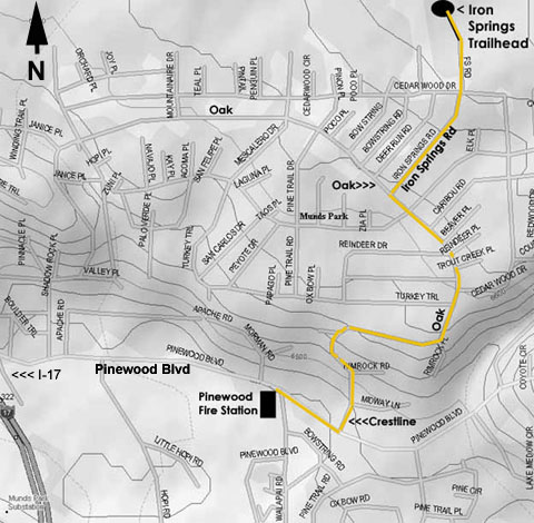
Munds Park Trail System-North - (Updated June 2019)
New map is in color, and includes CNF numbers and names.
Coconino National Forest Travel Map
This non-interactive version of the Travel Map, in color and with shaded relief, identifies the roads, trails, and areas designated for public motor vehicle use on Coconino National Forest lands, as well as popular Forest locations and destinations. These motorized travel designations apply only to National Forest System roads, National Forest System trails, and areas on National Forest System lands.
PDF Version - Large File, may take time to download (70 MB)
2023/2024 Motor Vehicle Use Map (MVUM)
The MVUM contains essential information about road, trail, and area designations that motorists should always have close at hand. The free published hard copy MVUM is the legal document-of-record that shows the roads, trails, and areas designated as open to motorized vehicle use on Coconino National Forest.
Driving a motorized vehicle on roads, trails, or areas not designated for motor vehicle use is prohibited.
Several formats of GPS-Enabled Maps for iOS and Android devices are available.
Download a Free App and GPS-Enabled Travel Maps for Your Device:

Avenza Maps can be viewed using the Avenza Map app.
Download The App From The App Store Or Google Play
Coconino National Forest Travel Maps: Free downloadable maps, which when loaded into the Avenzo Maps app above, shows all roads and trails that are open to public use, and when GPS tracking is enabled, will allow real time tracking of your location on the map.